[bob saw trebor's post and knew that to correct the broad range of misapprehensions contained within it would require extraordinary measures. therefore he spent the weekend searching for the fabled 'blackboard of instruction' (+2 vocabulary, +5 knowledge, +3 patience, +137 eraser throwing skills) but, alas, was unsuccessful. so he had to make do by equipping with his 'tobacco pipe of arrogant obsequiousness' (+7 @ss-kissing of superiors, +3 @buse of TA's, students and other inferiors, +507 differentiation between superiors/inferiors) and hope that it will suffice]
your explaination of L points is interesting
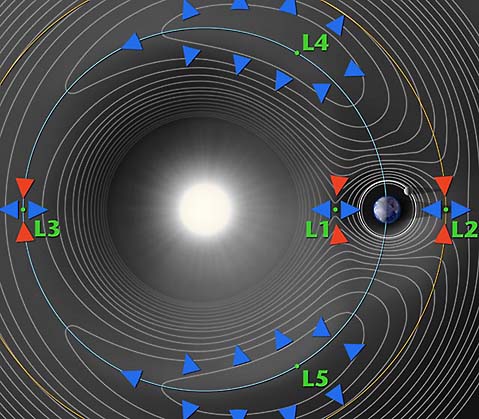
but NASA agrees with me (click on the hot link 'Lagrange points explained' or look at the properties of the graphic and you'll see a NASA web address)
isn't it 2 dimensional
yes, so? 3, 4, n-th dimension objects are represented in 2-d all the time. it may be partly a limitation of the tools that mankind has had to work with but it is very functional. if you know how to read the representation, it's also very exacting.
we have satellittes over the poles of earth in geo sync orbit
no, we don't. polar and geo-synchronous are both subsets of the term 'orbit' but they are mutually exclusive subsets.
[bob ponders how to explain this problem in text, it being the confluence of the fields of geography,cartography, basic physics, orbital mechanics, drafting]
an object in a polar orbit crosses over the poles. (i know, i know, you're saying 'duh') almost all objects in polar orbit cross over every part of the earth given sufficient orbits which is why these orbits are used for surveillance.
an object in geo-synchronous orbit is always
directly over the same lat/long coordinate on the surface of the earth. this is possible because
a) the rate of the earth's rotation at it's surface is slower than orbital velocity at that altitude ( 0' above sea level )
b) the velocity needed to maintain orbit decreases as altitude increases
this means that if you climb to a certain altitude over
and in the same plane/direction of rotation as the equator you can maintain your position over that part of the earth w/o expending any energy. this is how satellite TV ( all general purpose com-sats actually) works. you point your dish at a given point in the sky and you never have to change it because the satellite is not moving
in relation to you. if you were trying to pick up a signal from a polar satellite your dish would have to be constantly readjusting it's aim and you'd still lose contact >80% of the time because the bird would be over the horizon.
an L4 or L5 terra/luna orbit is actually a lunar orbit .... that the moon's mass/orbit stabilizes. ALL of the L points are dependent upon the orbit of the secondary body in the system pair for their stabilizing properties and therefore they must all lie on the plane of the ecliptic of the secondary body's orbit.
orbits over the sun's poles (solar-polar?

) and 'sol-synchronous' orbits are certainly possible but they wouldn't have any specific interest for anyone unless you were trying to avoid debris, do surveillance on the solar system or communicate with the surface of the sun.
couldnt we have the same thing around the sun?
i'm not certain how you intended this to be read. if you're asking 'are there Lagrange points on the sun/earth system' the answer is yes, sol/terra Lagrange points are what the in-lined graphic is actually showing. the sol/terra points wouldn't be nearly as convenient for human use because of the much greater lift requirements necessary to get to them. the terra/luna points would have much more utility because only a slight vector change would be required in order to land on either the earth or the moon while any space station positioned there would still be very close to sources of supply/rescue.
have i muddied things enough?